Toya Dubin, former Director of NAHC’s “Mapping Early New York” project
Of all our programs over the years, the jewel in our crown has been “Mapping Early New York.” Toya Dubin, until recently Director of the “Mapping Early New York” project for the New Amsterdam History Center has provided this account:
The Birth of a Vision (2006–2010)
“The Mapping Early New York” project was born out of a desire to bring the earliest phases of New York City’s complex urban and cultural history from the 17th century to life through online interactive, spatial storytelling that would engage and delight its users.
Conceived in the 2006-2007 by the New Amsterdam History Center (NAHC), the initiative eventually sought to use 3D Models, interactive maps, and a detailed encyclopedia to map and interpret the urban development, landholding patterns, and European, enslaved African, and Native American social networks of New Amsterdam as an outpost of the Dutch West India Company, and its transformation into New York under British rule.
A series of strategic meetings in 2006–2007 created the working title The Virtual New Amsterdam Project (VNAP). Spearheaded by Courtney Haff of Haff Associates and Casey Kemper of the Collegiate Church Corporation, the effort brought together a diverse team of artists, technologists, and historians to explore how digital tools could breathe life into the 17th-century world.
Initial collaborators included the Environmental Simulation Center, Hudson Microimaging, historical artist Len Tantillo, David Voorhees of the Holland Society, Dr. Charles Gehring of the New York State Archives, and Dr. Firth Haring Fabend, who led a team of scholars in shaping the historical foundation of the work. By 2008–2009, the New Amsterdam History Center had formally launched the VNAP with a preliminary 3D model and a rudimentary digital encyclopedia (then referred to as a database), containing names, occupations, property types, and documents sourced from partner organizations including the New York State Archives and the Holland Society of New York.
At this stage, the model was unpopulated, the Castello Plan existed only as a static image link, and the biographies of the city’s residents lacked depth—particularly in recognizing the roles of enslaved Africans and Indigenous peoples. Nonetheless, these early efforts laid the groundwork for a more robust, inclusive, and interactive project.
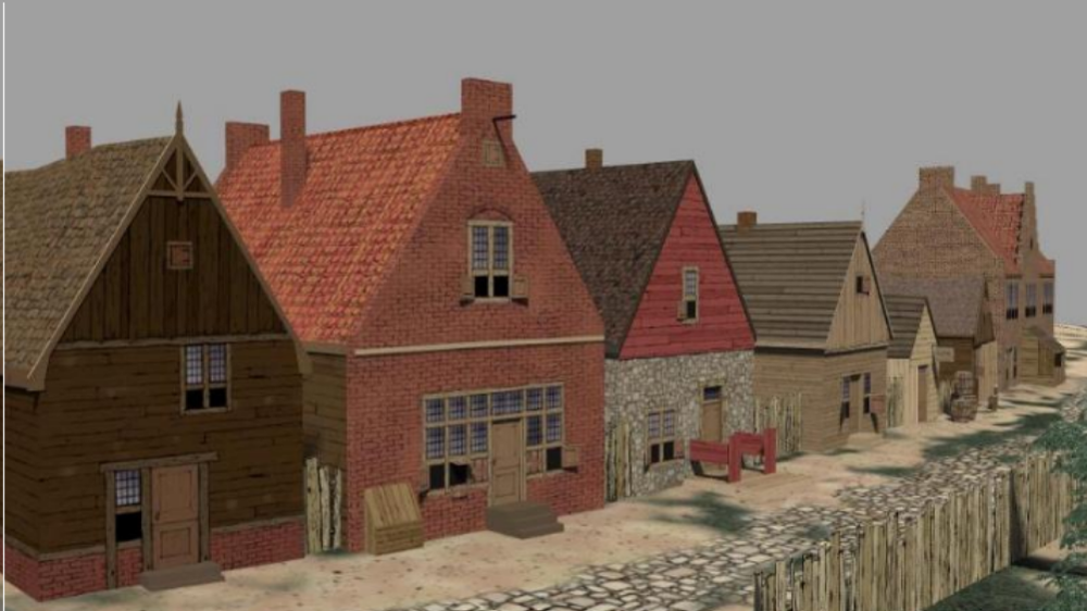
By 2011, a second iteration of the 3D model introduced “characters” drawn from 17th-century Dutch paintings and basic architectural features like Petrus Stuyvesant’s house and Stone Street. While much of the 3D model remained in simplified “brown box” form, the foundation had been laid for a more sophisticated integration of data, narrative, and spatial exploration.
Expansion, Mapping, and Inclusion (2010–2021)
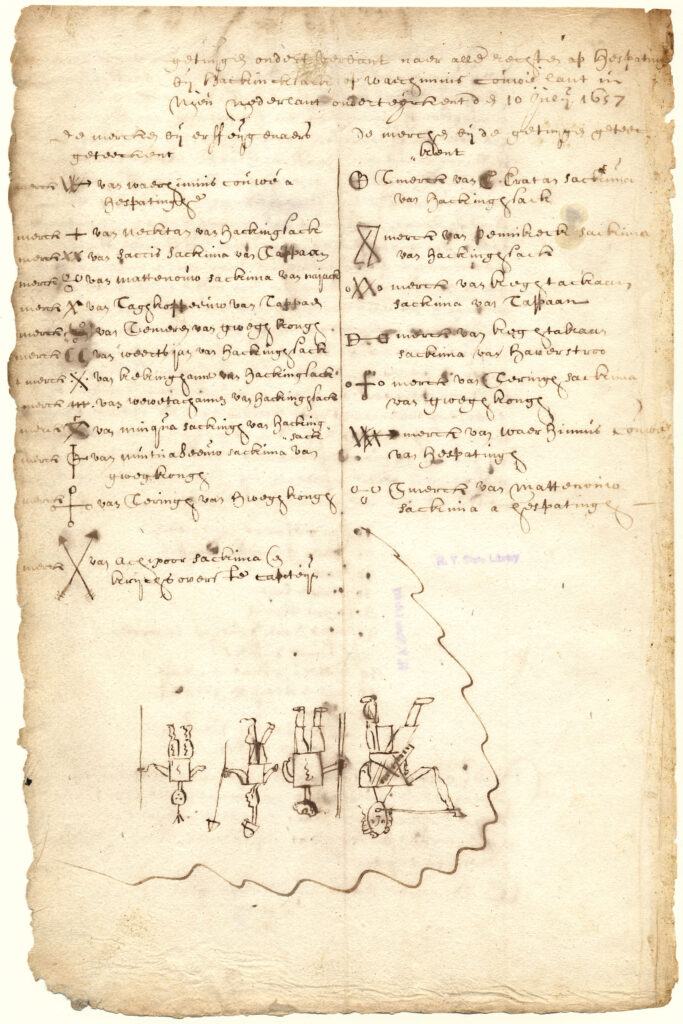
From 2010 through 2021, NAHC’s focus shifted toward deepening the documentary and cartographic layers of the project. The Encyclopedia grew to house many thousands of documents, maps, articles, and indexes. The New York State Archives and New York State Library’s Manuscripts and Special Collections departments became significant partners with more than 9,000 documents included in the Encyclopedia along with their translations. In addition, the New York City Municipal Archival provided more than 8,000 documents, so the search functionality became significantly better.
The mapping component—initially underdeveloped—began to take shape through collaboration with GIS mapping specialist Nitin Gadia.
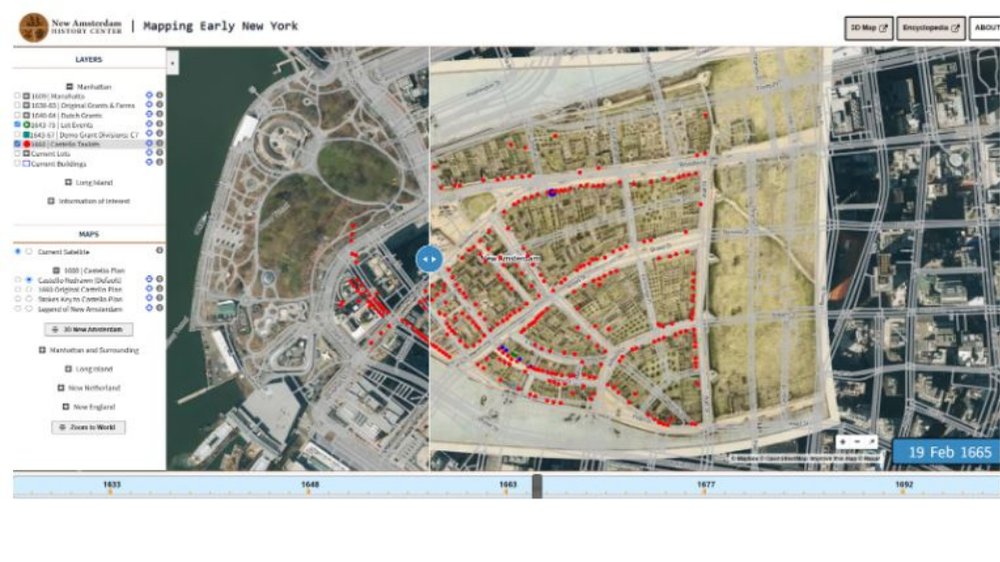
One of the most transformative additions during this period was the introduction of an interactive Castello Planlayered with property tax lots and linked entries in the Encyclopedia. This allowed users to explore the early city’s geography, social networks, and historical documents through a time slider interface. Support from institutions such as the New York State Archives (NYSA), the New York State Library (NYSL), the NYC Municipal Archives, and the New- York Historical Society was critical to expanding the Encyclopedia’s archival depth.
 In 2014, Toya Dubin and Nitin Gadia travelled to Albany to give a presentation to the New York State Archives demonstrating the potential for linking GIS information to Maps, 3D models, and the Dutch Documents Collection. This meeting included members of the NYS Archives, NYS Library, and NNI, all of whom were really enthusiastic about our concepts surrounding detailed GIS mapping and document search.
Some questioned the project’s scope and intended audience. The answer: “Yes, all of the above”—students, educators, scholars, genealogists, reenactors, and lifelong learners were all part of the intended community. The team likened their approach to Wikipedia: always expanding, never complete.
That same year, NAHC received funding from the Society of Daughters of Holland Dames (DOHD), enabling the addition of new maps such as the 1609 Manahatta Map, and features that highlighted Lenape trails, Dutch land grants, streams, and original coastlines. DOHD support also underwrote new research tools, including map layers, document finding aids, and family relationship functionality within the Encyclopedia.
What became evident as we proceeded is that the more research features we added, the better we could determine how to enhance the mapping, the encyclopedia, and eventually the model.
The project began to include enslaved and free African individuals, as well as Native Americans like Chief Oratam, through careful research into manumission papers, Indian deeds, and land records. These entries helped reclaim the dignity and visibility of people whose lives were often obscured in the historical record.
Toward Immersive Historical Experience (2021–Present)
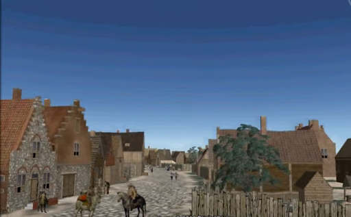
In 2021, NAHC partnered with Dutch 3D specialist Eduard van Dijk to connect the Encyclopedia, mapping tools, and 3D models into a more integrated research and storytelling platform. A major grant from the Gardiner Foundation enabled dramatic progress: detailed maps of Long Island were added, along with layers marking Indigenous villages, shipwrecks, cemeteries, and colonial settlements. For the first time, users could save research in personalized folders—making the platform classroom-friendly and fostering collaborative study.
By 2023–2024, the creative team now included Toya Dubin, Eduard van Dijk, Nitin Gadia, Jerry O’Toole, Mustafa Akbay, Drew Shuptar-Rayvis and author Russell Shorto. In preparation for the 2024 exhibit at the New-York Historical Society entitled “New York Before New York: The Castello Plan,” the team completed a ten-stop digital tour of 17th-century New Amsterdam. Each stop reflects a convergence of rigorous scholarship, cutting-edge digital design, and inclusive history:
- House of Enslaved Workers: AI-generated characters informed by fabric studies and archaeological finds
- Fort Amsterdam: Masonry work by enslaved Africans digitally reconstructed.
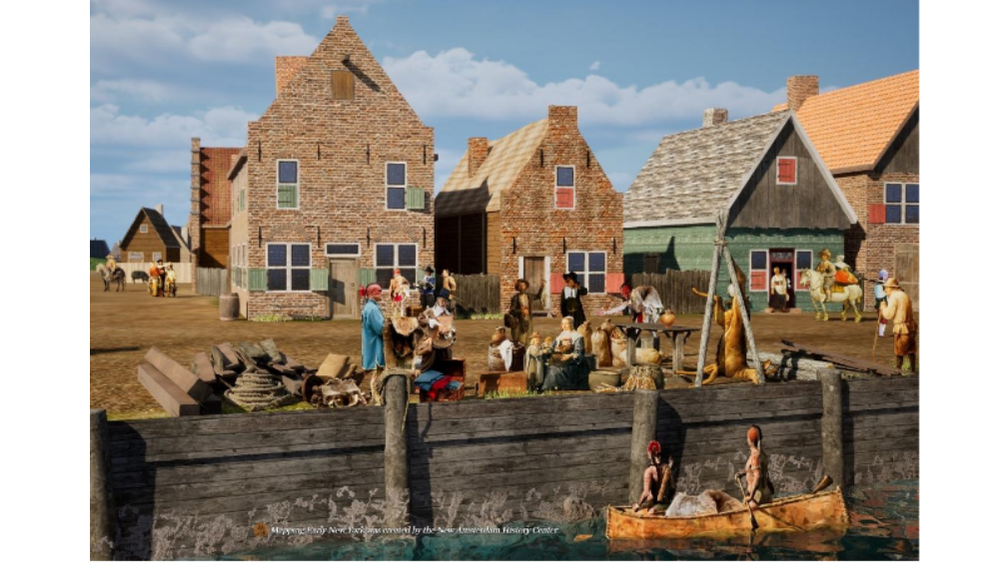
- Dock: Bustling with diverse populations unloading goods and animals.
- City Hall Gardens: Cultivated by DWIC-bound laborers growing crops for the settlement.
- Sara Kierstede House: Research revealed it as a key site for Indigenous trade and translation.
- Stone Church: Built from dressed stone per documents found that name the Ogden brothers of Stamford, CT., as the builders.
- The Wall and “Land of the Blacks”: Mapped using grants and tax lots to represent early Black landowners north of Wall Street.
The model also features gardens based on archaeobotanical evidence from Joel Grossman’s work—down to the purslane and cabbage grown in the Company Garden.
An additional 3D model based on the 1657 wreck of the Prince Maurice, was created in 2024. Placed on Long Island, it features a shipwreck and a Native American village complete with interior views of a long house that would have belonged to the Unkechaug tribe. Chief Harry Wallace of the Unkechaug Nation joined the creative team to assist our efforts and provided extensive interviews for use in the online presentations.
Though some elements, like detailed house interiors and the wreck of the Prince Mauriceremain in development, the project’s open-ended nature allows for continual enrichment.
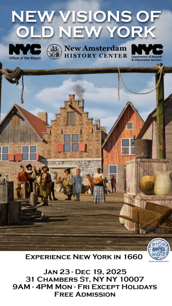
In 2025 the ongoing collaboration with the New York City Municipal Archives resulted in another exhibition, “New Visions of Old New York” featuring a very large touch screen to display the 3D model. Pauline Toole and Sylvia Kollar worked with Toya Dubin to create an exhibit that features the role of women, the enslaved, and the indigenous people in the 17th-century settlement that became New York City.
Looking ahead, NAHC aims to integrate global map overlays, connect 3D models to the time slider for dynamic historical visualization, and expand public and academic participation. The team is actively working to build 3D interiors of Sara Kierstede’s house and to implement user-suggested features, especially for schools and museums. Author Vanessa Bezemer Sellers became the Project Director in April of 2025 replacing Toya Dubin. Additional partnerships with archival organizations in the Netherlands and international exhibits are goals for 2025-2026.
Conclusion
The “Mapping Early New York” project represents nearly two decades of collaborative effort between historians, technologists, educators, archivists, and community members. What began as a modest virtual model has grown into an expansive, interactive archive that honors the complex, diverse heritage of 17th-century New York.
None of this would have been possible without the support of the Society of Daughters of Holland Dames, the Robert David Lion Gardiner Foundation, the Consulate General of the Kingdom of the Netherlands, Ken Chase, the First Families Foundation, and the many supporters of the New Amsterdam History Center. Their financial, scholarly, and moral commitment continues to fuel our shared mission: to bring the early history of New York to life with integrity, imagination, and scholarly rigor.
To explore the project, please visit:
🔗 https://newamsterdamhistorycenter.org/learn-explore/the-castello-plan-new-amsterdam-in-1660/
🔗 https://nahc-mapping.org/mappingNY
🔗 https://encyclopedia.nahc-mapping.org