Ina L. Selden
Not just any park, but Central Park. And not just any part of the park, but the extreme north end, 110th to 103rd, between Fifth Avenue and Central Park West. And not just with any guide, but Sara Cedar Miller, former official photographer for the Central Park Conservancy and its official historian for 28 years. Sara’s latest book, Before Central Park, tells the “pre-park” story of the unusual topography of this section of the park and how it played a key role in New York City’s history.
On June 6, the New Amsterdam History Center trustees hosted donors, members, and their guests for an hour’s walk through a section of the park’s 843 square acres rarely explored by its annual 42 million visitors, let alone the city’s 8.5 million inhabitants. At every step, we benefited not just from Sara’s keen eyes but also her deep knowledge of the landscape and New York City history. Here are highlights from the tour and comments from some of NAHC’s guests:
“Central Park is so often understood as a terrific work of design and landscaping that we lose sight of its natural terrain and how it was used before it became a park. Sara Cedar Miller’s tour alerted me to the Park’s distant past and how it endures in the present, in everything from rocky outcrops to colonial roads. My future walks in the park will be richer and more rewarding for her tour.”
Robert W. Snyder, Manhattan Borough Historian, Professor Emeritus, Rutgers University.
In 1637, the Walloon De Forest family arrived in New Amsterdam. The family leaders had traveled for years in search of a welcoming place for their fledgling religious community. They chose New Amsterdam for its tradition of Dutch religious toleration. Having lived in Leiden for years they were familiar with Dutch manners and traditions. In 1638 the Dutch West India company granted the De Forests use of acreage at the extreme north end of Manahatta. The land was fertile, flat, and well served by a fresh-water creek.

Today The Mount refers to one of the park’s composting areas. But in 1847 the area was developed and inhabited by the Sisters of Charity of Mount St. Vincent who ran a boarding school on pre-Park land. The Parks Department envisaged the property as a museum, but instead it became a hospital for Union soldiers during the Civil War. A fire destroyed the buildings in 1881. The restaurant was rebuilt and named McGowan’s Pass Tavern. Only the stone foundation of the chapel remains as a reminder of the area’s rich architectural history.


One of the first stops on our tour was Fort Clinton, a massive 140- foot-high bedrock outcropping set between the park’s two highest points. The panoramic view explains why the hill was strategic for both Washington and the British during the Revolutionary War.
The Black Horse Tavern once stood on the nearby Wickquasgeck Trail. We walked the pass blazed by Indigenous hunters, favored by wild animals, used by both Washington’s Continental Army and the British and Hessian troops to conduct offensives and lead retreats.
Yale historian Alan Mikhail, currently writing a book about the family of New Netherland’s purported only Muslim resident, observed: “Walking around Central Park with Sara Cedar Miller was like walking around it for the first time. Places one has passed hundreds of times suddenly revealed their Dutch past. Tracing the Wickquasgeck path through what is today McGowan’s Pass was especially thrilling. After being unearthed about a decade ago, it is now covered over again, with little indication of what lies beneath. One hopes this site gets the attention it deserves.”
When a water feature on the original itinerary was blocked by construction work, Sara quickly led us to a rocky waterfall. “Olmsted and Vaux wanted a park for all the people,” she said. “The rich could journey to the Adirondacks at will, not a luxury the working class could enjoy. So, they created the Adirondacks in the city.”
Most of our guests that day were native or long-time New Yorkers. But like so much else on our tour, they had little idea that The Mount, a convent, once stood on a hill next to the Harlem Meer.
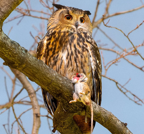
“What I enjoyed most was seeing the park through Sara’s eyes as a photographer and naturalist. Her acute sense of scale and height at the varying levels of the park terrain enhanced the tour for me. I was able to view the Park through her photographer’s eye. The Adirondack waterfall was also news to me – another part of the Park I hadn’t known before, shocking to me as I grew up right across the street! An unexpected treat was catching a glimpse of Flaco* on a compost pile.“
Joanna Cawley, Executive Director, Carnegie Hill Neighbors, a non-profit dedicated to preserving the residential character and architectural heritage of Carnegie Hill and enhancing quality-of-life programs that maintain the neighborhood as a safe and beautiful place to live.
“Sara’s tour made me feel as if I was stepping back in time as I listened to her descriptions of the life of the early Dutch settlers in its northern part. I will also always remember that walk as the first night the smoke from the Canadian wildfires arrived in NYC. We emerged from the Park into the sepia haze that had descended upon the entire city.”
Barbara McLaughlin, President, Fund for Park Avenue. The Fund is responsible for planting and maintaining the trees and flowers on the Park Avenue Malls between 54th and 86th Streets through and also manages the annual Park Avenue Tree Lighting.


